The research team led by Associate Professor Song Xiaoquan from Ocean University of China utilized the Wind3D 6000 Doppler wind lidar from Qingdao Leice to observe the characteristics of sea and land winds in the Huludao area and analyze their impact on ozone pollution. The related results were published in the Journal of Optics and selected as a highlight article in the Space, Atmospheric, Oceanic and Environmental Optics (SAME) special issue. The team uses LiDAR to capture the fine structure of sea and land winds, and combines it with a mesoscale WRF model to study the effect of sea and land wind circulation on local ozone pollution, providing new ideas for local meteorological pollution research.
Original link: Yang Yawen, Song Xiaoquan, Lian Wenchao, Kang Boshi, Miao Chuanhai The characteristics of sea and land breeze in Huludao in spring 2021 and its impact on ozone pollution [J] Journal of Optics, 2023, 43 (12): 1228002
一
Sea and Land Breeze and Coastal Air Quality
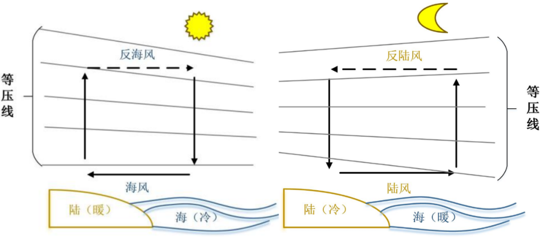
Land sea breeze is a mesoscale atmospheric physical phenomenon that occurs on different underlying surfaces of land and sea, and its formation mechanism is the temperature differences and changes between land and sea. The specific heat between land and sea is different. During the day, the land surface heats up quickly, causing the air to expand and rise. The pressure above the land surface is higher than that of the ocean, and the air flows from the land to the ocean; The surface pressure of the ocean rises, forming sea winds blowing from the ocean towards the land near the surface. This kind of opposite circulation movement in space is called sea breeze circulation, and the process at night is opposite to it, forming land breeze circulation.
The tropospheric ozone is mainly generated by a series of photochemical reactions of volatile organic compounds such as nitrogen oxides, and is influenced by various meteorological conditions such as radiation, temperature, boundary layer diffusion conditions, and local circulation. The special meteorological conditions and local circulation structure of sea and land winds have a significant impact on the transport and diffusion of ozone in coastal areas.
Huludao City is located south of Bohai Bay, with a complex coastline and a frequent occurrence of sea and land winds. As an important port city in the coastal economic zone of Liaoning, regional composite pollution characterized by ozone and fine particles is becoming increasingly severe. This study investigates the impact of sea and land breeze circulation on local environmental quality, especially ozone pollution, from the perspective of local meteorology. It provides relevant references for other cities in the Bohai Rim region and theoretical basis for the prevention and control of ozone pollution in the Huludao area.
二
Observation of Sea Breeze Structure by Doppler LiDAR
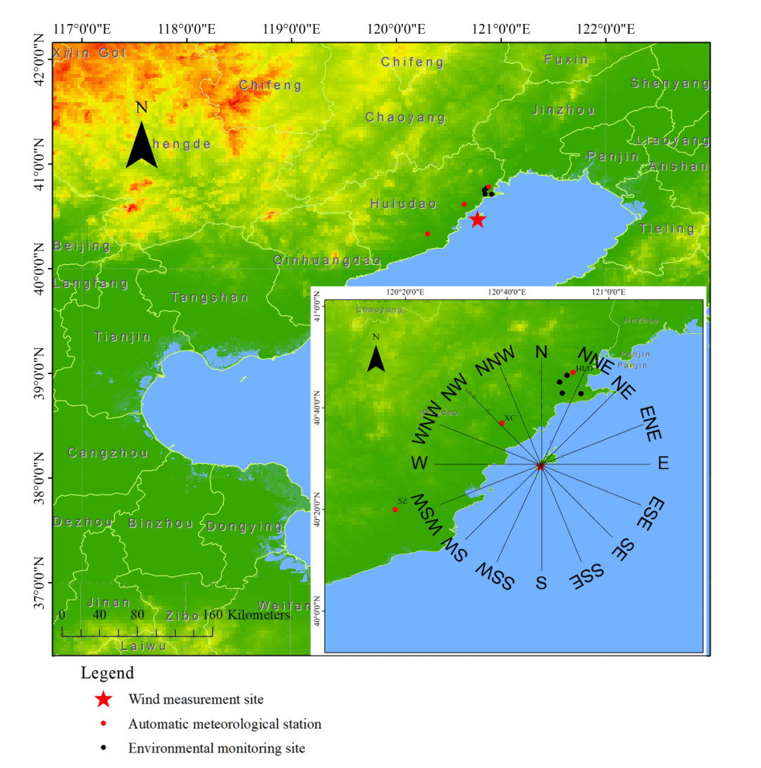
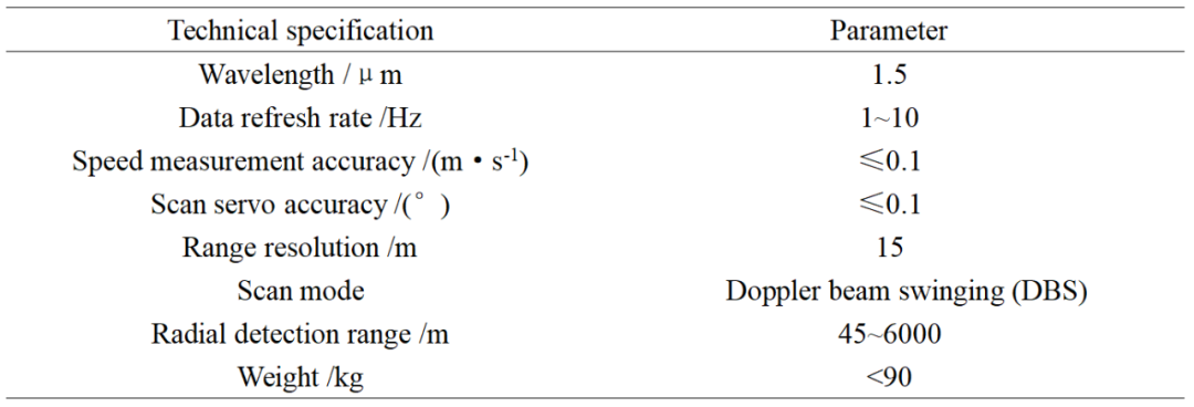
The Wind3D 6000 coherent Doppler lidar developed by Leice is of high spatiotemporal resolution and can obtain precise three-dimensional wind fields in the atmospheric boundary layer. From March 1 to April 30, 2021, the Wind3D 6000 system was installed on the southwest side of Juehua Island in Huludao City, Liaoning Province (120 ° 47'E, 40 ° 29'N) for three-dimensional wind field observation.
Technical Parameters of Wind3D 6000
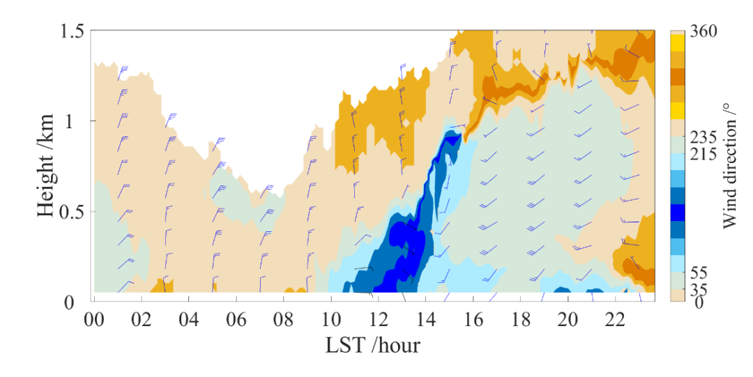
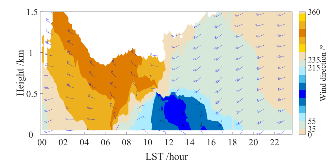
Doppler LiDAR can provide high spatiotemporal resolution data of the vertical structure and development process of sea breeze circulation. As shown in Figure 3, land winds dominate in the early morning and nighttime, while sea breeze landfall is concentrated in the morning. During the development of sea breeze, the direction of the wind deviates clockwise. Compared to near ground conditions, the formation of high-altitude sea winds lags behind and has a shorter duration. While during the sea breeze phase, northbound land winds can still be observed at high altitudes, forming a sea breeze circulation.
(b)
(a) April 4, 2021; (b) April 14, 2021
The WRF model for mesoscale weather forecasting is an effective tool for simulating urban scale to mesoscale range meteorological conditions. In order to study the development process of sea and land breeze in the region, this article uses the WRF model to simulate the sea and land breeze on April 4, 2021. The simulation results in Figure 4 show that as the difference in thermal properties between land and sea increases, sea winds from low latitude areas make landfall along the coast of Huludao; At 12: 00, the meridional wind in the area covered by sea breeze is 5-8 m/s, and the sea breeze develops more vigorously, with a sea breeze head height of 750 m; At 14:00, the sea breeze penetrates inland, forming a clear sea breeze circulation.
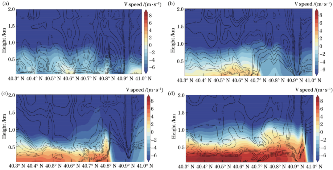
Figure 4: Daily vertical wind and temperature fields of sea land winds based on WRF model
(a) 08:00; (b) 10:00; (c) 12:00; (d) 14:00.
三
Sea Breeze Recycling and Ozone Pollution
This article combines hourly wind speed, direction, temperature, and ozone mass concentration data obtained from Huludao automatic meteorological station and environmental monitoring station to study the trend of ozone concentration changes during sea and land breeze periods. When there is or no sea and land breeze, the daily variation of local ozone concentration shows a "single peak" trend; In the early morning stage, continuous land winds transport urban pollutants to the ocean; After sunrise, with the increase of solar radiation, the concentration of ozone increases, with a faster rise rate and higher peak concentration during sea and land breeze periods.
During the circulation of sea and land winds, offshore land winds blow local pollutants towards the ocean; The daytime sea breeze makes landfall, bringing back air masses transported by the land breeze to the sea and causing the accumulation of pollutants, which is the main reason for the higher peak concentration of ozone during the sea land breeze period. Local recirculation (R) describes the phenomenon of pollution being transported out of space by a wind field and then transported back. This index was proposed by Allwine and Whiteman et al. to characterize the transport capacity of a wind field.
Research Group
Source: AOX WeChat official account